


GeoEvident
What is GeoEvident?
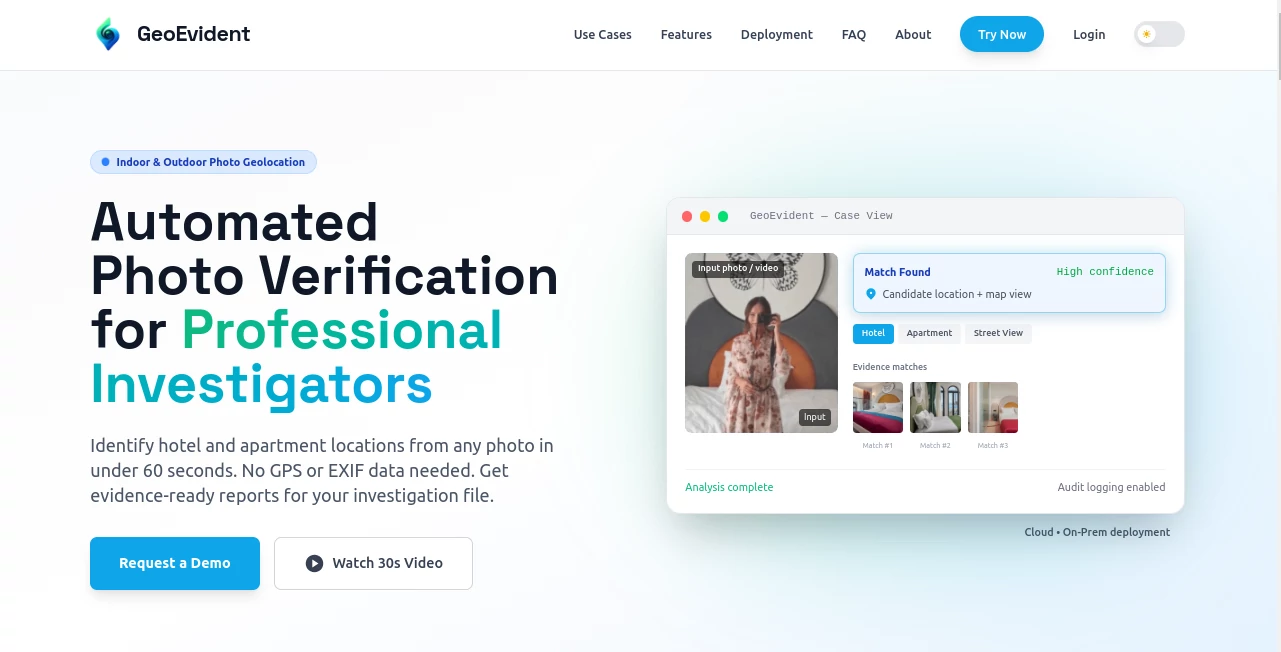
Finding the exact location where a photo was taken can be one of the most challenging parts of an investigation, especially when GPS coordinates or EXIF metadata are missing. This platform is purpose-built to solve that problem by analyzing visual clues inside images and video frames, helping investigators identify hotels, apartments, streets, and other real-world locations with remarkable speed.
Unlike traditional reverse image search solutions, it focuses on evidence-backed geolocation rather than simple visual similarity. Every result is supported by comparable visual matches, allowing investigators, journalists, insurance teams, compliance professionals, and security analysts to validate findings before making decisions. The combination of AI-powered computer vision, structured reporting, and enterprise-grade security makes it an impressive solution for organizations handling sensitive investigations.
Key Features
User Interface
The interface is designed for professional investigative workflows. Uploading an image or extracting frames from a video takes only a few moments, after which the system presents ranked location candidates alongside supporting evidence. Maps, comparison images, analyst notes, and report generation are all organized in a clean workspace that reduces manual effort during investigations.
Accuracy & Performance
Instead of relying on metadata, the platform studies architectural details, furniture layouts, street signs, landmarks, room designs, lighting conditions, and numerous other visual indicators. The AI then ranks possible locations based on confidence while allowing analysts to verify every suggested match. This evidence-first approach helps reduce uncertainty and supports more reliable conclusions.
Capabilities
- Indoor photo geolocation for hotels and apartments.
- Outdoor street and landmark identification.
- Video frame analysis.
- Visual evidence comparison.
- Ranked location candidates.
- Case-ready investigation reports.
- Analyst note management.
- Audit logging.
- Role-based access control.
- Cloud deployment.
- On-premise deployment.
- Air-gapped deployment for sensitive environments.
Security & Privacy
Security has clearly been considered from the beginning. Organizations can choose between managed cloud infrastructure or fully isolated on-premise deployments depending on operational requirements. Role-based permissions, audit logs, controlled access, and enterprise deployment options help maintain accountability throughout every investigation. These features make the platform suitable for organizations that require strict governance and documented workflows.
Use Cases
- Open-source intelligence (OSINT) investigations.
- Law enforcement and digital forensics.
- Insurance fraud investigations.
- Corporate security operations.
- Compliance and AML verification.
- Investigative journalism.
- Border security investigations.
- Rental property verification.
- Hotel identification from interior photographs.
- Verification of social media imagery.
Pros and Cons
Pros
- Highly specialized for professional geolocation investigations.
- Works without GPS or EXIF metadata.
- Supports both indoor and outdoor images.
- Produces evidence-backed location candidates.
- Generates structured investigation reports.
- Strong enterprise security features.
- Flexible deployment options.
- Designed for collaborative investigative teams.
Cons
- Built primarily for enterprise and professional users.
- Image quality influences overall accuracy.
- Analysts should review suggested matches before reaching final conclusions.
- Pricing information is not publicly available.
Pricing Plans
Public pricing is not listed. Organizations can request a demonstration and discuss deployment requirements, evaluation criteria, and licensing options based on their operational needs. Both cloud and on-premise implementations are available for enterprise customers.
How to Use GeoEvident
Start by uploading a photograph or selected video frame into the investigation workspace. The AI examines visual elements such as room layouts, architecture, street features, furniture, and distinctive environmental details. Within a short period, ranked location candidates appear together with supporting visual comparisons. Analysts can review the evidence, document observations, generate a professional case report, and export findings for future investigation or compliance records.
Comparison with Similar Tools
Many image search platforms focus on finding visually similar content across the web, but they often lack investigative workflows and structured evidence. This solution takes a different approach by emphasizing forensic documentation, analyst validation, auditability, and enterprise deployment. Instead of simply suggesting possible matches, it presents verifiable evidence that professionals can examine before making operational decisions. This distinction makes it particularly valuable for organizations where accuracy, documentation, and accountability matter as much as speed.
Conclusion
For professionals who regularly investigate digital imagery, this platform offers an outstanding balance of artificial intelligence, computer vision, and investigative workflow management. Its ability to identify probable locations from challenging indoor and outdoor photographs, combined with evidence-backed reporting and enterprise-grade security, creates a dependable solution for modern investigative teams. Whether supporting fraud detection, compliance reviews, journalism, or forensic investigations, it significantly reduces the time required to transform a single image into actionable intelligence.
Frequently Asked Questions (FAQ)
Can it identify locations without GPS metadata?
Yes. The system analyzes visual information inside images instead of relying on EXIF or GPS data.
Does it support indoor photographs?
Yes. Hotel rooms, apartments, rental properties, and other indoor environments are among its primary strengths.
Can video files be analyzed?
Yes. Video frames can be extracted and processed using the same AI-powered geolocation workflow.
Is it suitable for enterprise investigations?
Yes. The platform includes role-based access control, audit logging, structured reporting, and flexible deployment options designed for professional organizations.
Is pricing publicly available?
No. Interested organizations need to request a demonstration to discuss deployment options and licensing.
AI Image Recognition , AI Developer Tools , AI Research Tool , AI Productivity Tools .
These classifications represent its core capabilities and areas of application. For related tools, explore the linked categories above.
GeoEvident Alternatives Product

MidJourney

CodeProt

TrueSource AI

Nifty
Rierino

Blackbox AI

Liftburst
photo to URL

Coresite