


















Where Is This Place
What is Where Is This Place?
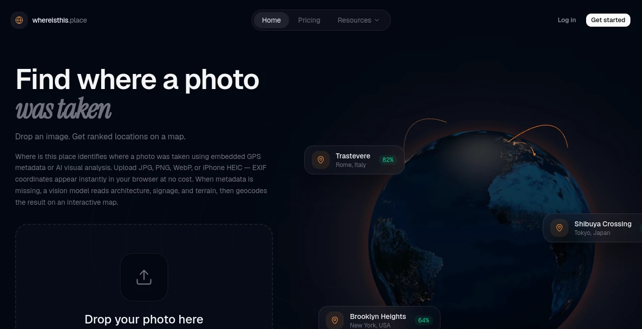
Ever come across a photo and wonder exactly where it was taken? Where Is This Place is built to answer that question without forcing you to rely entirely on visual guesswork. It combines AI-powered image geolocation with free EXIF GPS extraction, giving users a practical way to investigate the location behind a photograph.
The service is particularly useful when a picture has little or no context. A street scene, landscape, building, travel photograph, or image discovered on social media can contain visual clues that are difficult to interpret manually. The platform examines those clues and can provide ranked location predictions, including the city and country, along with confidence information.
One detail that makes the approach especially useful is the two-path workflow. If an image still contains GPS information in its EXIF metadata, that information can be extracted directly in the browser for free. If the metadata is missing or unreliable, AI-based visual analysis can take over and examine elements such as architecture, signs, vegetation, and terrain.
Key Features
- AI-powered photo geolocation based on visual clues.
- Free EXIF GPS extraction directly in the browser.
- Ranked location predictions with confidence scores.
- City and country identification for analyzed images.
- OpenStreetMap-based geocoding for location results.
- Up to five possible location predictions when AI analysis is used.
- No account required for free EXIF extraction.
- Images are processed in memory and discarded after analysis.
- Designed specifically for scenes and environments rather than identifying people.
- Useful tools and resources for research, verification, and OSINT workflows.
User Interface
The interface follows a straightforward upload-and-analyze concept, which is exactly what this type of service needs. There is no reason to overwhelm users with complicated mapping controls before they have even analyzed a photograph. The workflow keeps attention on the image and the resulting location information.
The distinction between metadata extraction and AI analysis also makes the experience easier to understand. Users can quickly determine whether a photograph already contains useful GPS information or whether deeper visual analysis is necessary.
Accuracy & Performance
Photo geolocation is rarely a matter of simply recognizing one landmark. Many images contain subtle clues, and the correct location may depend on combining several of them. The visual analysis system considers details such as architecture, signage, vegetation, and terrain before producing ranked predictions with confidence scores.
This approach is more useful than presenting a single location as an unquestionable fact. A ranked list gives researchers and curious users a starting point for further verification. When EXIF GPS data is available, the process is even more direct because the embedded coordinates can be displayed without consuming an AI search credit.
Capabilities
The platform covers two complementary methods of photo location analysis. The first is EXIF inspection, which can reveal GPS coordinates embedded in the original image. This part happens inside the browser and is available without charge.
The second method uses visual AI when metadata cannot provide the answer. The system can examine environmental and visual characteristics and return several possible locations instead of forcing an uncertain guess into a single result.
This combination makes the service suitable for everything from checking an old travel photograph to investigating an unfamiliar image encountered during online research. It is also designed around location intelligence rather than people identification, with facial recognition and people lookup outside its intended scope.
Security & Privacy
Privacy is one of the more notable aspects of the service. Uploaded photographs are processed in memory and discarded rather than being stored as a permanent collection. The site explicitly states that it does not store users' original photos.
The privacy model is particularly relevant for journalists, researchers, and OSINT users who may need to analyze photographs without creating an unnecessary archive of sensitive visual material. The product is also deliberately focused on places and environments rather than surveillance or identifying individuals.
Use Cases
- Travel research: Identify the possible location of an unfamiliar travel photograph.
- Journalism: Investigate the origin or geographic context of an image before using it as a source.
- OSINT research: Generate location leads from environmental and architectural clues.
- Source verification: Check whether the claimed location of a photograph appears consistent with its visual evidence.
- Historical photo research: Investigate photographs whose original metadata or context is no longer available.
- Social media research: Examine location clues in photographs shared without useful captions.
- Personal curiosity: Find out where an interesting landscape, street, or building might have been photographed.
- Field research: Use location predictions as a starting point for further geographic investigation.
Pros and Cons
- Pros: Combines EXIF extraction and AI geolocation in one workflow.
- Pros: EXIF GPS extraction is free and does not consume credits.
- Pros: AI results can include multiple ranked predictions instead of one unexplained answer.
- Pros: Confidence scores make uncertain results easier to evaluate.
- Pros: Images are processed in memory and discarded.
- Pros: Useful for journalists, researchers, travelers, and OSINT work.
- Cons: AI geolocation cannot guarantee the correct location for every photograph.
- Cons: Images with few distinctive geographic clues can be difficult to identify accurately.
- Cons: Regular AI searches require credits once the free allowance has been used.
Pricing Plans
The pricing structure is simple and separates free metadata extraction from paid AI analysis. New users receive one free credit after signing up, while EXIF GPS extraction remains free regardless of credit usage.
- Free: $0, including one free credit on signup, full results for logged-in users, and unlimited free EXIF extraction.
- Wallet: $15.90 as a one-time payment for 20 searches. These credits never expire and do not require a subscription.
- Pro: $59.90 per month for 100 credits, priority processing, and full search history.
- Enterprise: Custom volume, SLA options, team accounts, and dedicated support.
The pay-as-you-go option is especially appealing for occasional research because unused wallet credits do not expire. Regular users can instead choose the monthly plan and receive a larger recurring allowance.
How to Use Where Is This Place
Start by selecting a photograph whose location you want to investigate. If the file contains embedded GPS information, the EXIF route can reveal the coordinates directly in the browser without using an AI credit.
If useful GPS metadata is unavailable, submit the image for visual analysis. The AI examines geographic clues in the photograph and returns ranked location possibilities with confidence information. Review the suggestions rather than treating the first result as absolute proof, especially when the image contains generic scenery.
For research-heavy tasks, the results can then be compared with other evidence such as visible signs, maps, landmarks, architectural details, or the original context in which the image was published.
Comparison with Similar Tools
Traditional reverse image search is primarily designed to find visually similar or previously indexed images, while dedicated photo geolocation focuses more directly on answering the geographic question. This service takes a different route by combining metadata inspection with visual reasoning.
Another advantage is the presentation of multiple predictions and confidence scores. Instead of hiding uncertainty behind a single location, the results can provide several possibilities that users can investigate further. For researchers, that distinction can make the output more useful as an investigative lead.
The free EXIF workflow is also a practical addition. When coordinates are already embedded in a photograph, there is little reason to spend an AI credit analyzing visual clues that the file itself can reveal.
Conclusion
Finding the location behind a photograph can be surprisingly difficult when there is no caption, landmark, or obvious metadata to guide the search. This platform makes the process considerably more approachable by bringing EXIF extraction and AI-powered visual geolocation together.
Its strongest quality is the practical balance between automation and investigation. Users get fast location clues, but the ranked predictions and confidence scores leave room for human verification. Combined with a privacy-focused approach and a free EXIF path, it is a useful option for anyone who regularly needs to answer the deceptively simple question: where was this photo taken?
Frequently Asked Questions (FAQ)
Can I find a photo's location using EXIF data?
Yes. If a photograph contains GPS information in its EXIF metadata, the coordinates can be extracted directly in the browser. This feature is free and does not use AI search credits.
What happens when a photo has no GPS metadata?
The image can be analyzed using visual AI. The system examines clues such as architecture, signs, vegetation, and terrain and can return ranked location predictions with confidence scores.
Does the service store uploaded photos?
No. The service states that photographs are processed in memory and discarded rather than stored as original uploaded images.
How many AI searches are included for free?
New users receive one free credit after signup. Each AI photo analysis uses one credit, while EXIF GPS extraction remains free.
Do paid wallet credits expire?
No. The one-time wallet credits do not expire, allowing users to use their searches whenever they need them.
Is it designed to identify people?
No. The service is designed for geolocating places and environments. Facial recognition and people lookup are outside its intended scope.
AI Image Recognition , AI Image Scanning .
These classifications represent its core capabilities and areas of application. For related tools, explore the linked categories above.
Where Is This Place details
Website unavailable — View Alternatives
Pricing
- Free
Apps
- Web App
Categories

Where Is This Place Alternatives Product

Zush

TextSharp | …

deck cleaner

Wild and Fre…

Ultralytics

Face Shape D…

AI Image Enh…

FacialHarmon…

PlateLens
